
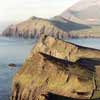
Slea Head Drive is a circular route of roughly 47 kilometres, running westward from Dingle town around the tip of the Dingle Peninsula and back again. It is one of the best-known scenic roads in Ireland, and it packs coast, mountain, archaeology and language into a single half-day journey for those who take it slowly.
Reading the route
The loop begins and ends at Dingle in County Kerry. Most travellers head out through Ventry, though either direction works, and the road is narrow enough that taking the route in the usual direction avoids awkward meetings with oncoming buses. Allow more time than the distance suggests, because stopping places are frequent and the light changes constantly.
Ventry and Fahan
Ventry (Ceann Trá) is a long, sheltered beach with a village at its edge. Beyond it the road climbs into the townland of Fahan, which is notable for its dense scatter of ancient remains: dry-stone huts, promontory forts and field systems on the slopes of Mount Eagle. These mixed remains are why the area is often described as an open-air museum.
Slea Head and Dunmore Head
At Slea Head, the road bends around a headland high above the water. On a clear day the Blasket Islands appear offshore, and the view south across Dingle Bay reaches the mountains of South Kerry. Dunmore Head, close by, is the westernmost point of mainland Ireland.
Dún Chaoin and the Blaskets
Further on lies Dún Chaoin (Dunquin), a Gaeltacht district where Irish is still spoken daily. The Great Blasket Island, now uninhabited, was home to a small community until the early 1950s and is remembered for a remarkable body of memoir and storytelling written by islanders. A visitor centre in the area interprets that heritage.
Back toward Dingle
The return leg passes more small settlements and, depending on turnings taken, the Gallarus Oratory, an early Christian stone chapel often described as shaped like an upturned boat. Its dry-stone walls have remained watertight for many centuries.
Practical notes
- Weather. Cloud can close in quickly on the headlands. Bright mornings and late afternoons usually give the clearest views.
- Roads. Expect narrow lanes, stone walls and sheep. Pull in at proper laybys and never block a gateway.
- Language. Road signs in the Gaeltacht may appear in Irish only. A short list of place names helps.
- Footwear. Fields beside the road are working farmland and can be soft or steep. Respect gates and livestock.
Why the details matter
Slea Head can be driven quickly, but its real character shows when you stop. A beehive hut in a field, a ruined cottage on a hillside, a cliff path eroded by the Atlantic or a hand-built wall dividing small plots all reveal how people once lived here. Many of them date from the nineteenth century, when farming families managed on a few acres, fished from small boats and watched the horizon for weather.
If you are planning a trip, check opening arrangements for any sites directly with their operators, as seasonal patterns change. Whatever the time of year, the Dingle Peninsula repays patience, and the best way to enjoy Slea Head Drive is to treat it as a series of short walks joined by a road.